

Urban Planning of Bamenda III Landscape, Cameroon: 4 Proven Strategies
INTRODUCTION
Urban planning of Bamenda III landscape, Cameroon, faces a profound and escalating crisis driven by the rapid, unregulated proliferation of squatter settlements, highlighting a critical intersection of rural-urban migration, topographical vulnerability, and municipal governance.

This summary translates the academic evaluations of squatter development into accessible, actionable insights for global housing professionals, urban planners, and researchers. Understanding the urban planning of Bamenda III landscape is essential for any city facing fast, unplanned growth on hilly terrain.
To critically assess the impact of squatter settlements on the municipality, the study employs a robust, mixed-methods research design tailored to the unique geographical and administrative context of the region. Evaluating informal development in a hilly, rapidly urbanizing area requires looking beyond standard administrative records, which frequently fail to capture the reality of informal land occupation.
The methodology integrates spatial analysis and Geographic Information Systems (GIS) mapping to track historical land-use changes, specifically the conversion of agricultural and forested lands into high-density, informal residential zones. Complementing the spatial data, the research utilizes structured household surveys to capture the socio-economic profiles, migration histories, and livelihood strategies of the squatters.
Furthermore, Key Informant Interviews (KIIs) with officials from the Bamenda City Council, urban planners, and local traditional authorities, alongside Focus Group Discussions (FGDs) with settlement residents, provide deep qualitative insights into the governance vacuums and land tenure disputes inherent in this transition.
This tripartite approach ensures a holistic understanding of how informal settlements alter the physical and social fabric of the municipality, and how the urban planning of Bamenda III landscape must respond.
ALSO READ: Explore More Housing and Urban Development Insights from ACASH
Defining the Core Concepts: Squatter Settlements and the Urban Landscape
Before analyzing the systemic impacts, it is essential to define the operational parameters of the study, as the terminology used in Cameroonian urban geography carries specific legal and spatial implications.
Squatter Settlements: In the context of this study, squatter settlements are defined as informal residential developments established on land to which the occupants have no legal claim, right, or formal lease. In Bamenda III, these settlements typically emerge through the unauthorized subdivision of customary or state land, characterized by self-built, substandard housing and a complete absence of formal municipal planning or infrastructure.
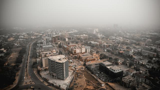
The Urban Landscape of Bamenda III: Bamenda III is a municipality characterized by a highly undulating, hilly topography and fertile volcanic soils. Historically an agrarian and peri-urban area, it has been rapidly absorbed into the expanding metropolitan footprint of Bamenda. The “landscape” in this context refers not just to the physical terrain, but to the spatial morphology, environmental ecology, and the statutory planning frameworks intended to manage this specific geographical zone. These factors shape every decision in the urban planning of Bamenda III landscape.
The Mechanics of Squatter Settlement Development in Bamenda III
The study reveals that the development of squatter settlements in Bamenda III is driven by a complex interplay of socio-economic pressures and institutional failures. These pressures sit at the heart of the urban planning of Bamenda III landscape.
Drivers of Informal Expansion
The primary catalyst for squatter development is the massive influx of rural-urban migrants and the natural population growth of the city. Driven by the search for economic opportunities and the high cost of formal housing in the city center, low-income populations are pushed toward the peripheries. Bamenda III, with its relatively lower land prices and proximity to the urban core, becomes a prime target.
Furthermore, the study highlights that the weak enforcement of statutory planning laws and the ambiguous nature of customary land tenure create a governance vacuum, allowing informal land brokers to illegally subdivide and sell agricultural or state land to desperate home-seekers.
Spatial Patterns and Topographical Vulnerability
A critical finding regarding the spatial development of these settlements is their location. Because prime, flat land is either too expensive or already formally developed, squatter settlements in Bamenda III predominantly occupy marginal, hazardous lands. The research notes a heavy concentration of informal housing on steep hillsides, valley bottoms, and along natural water drainage channels.
This spatial pattern is not merely a result of poverty, but a direct consequence of being excluded from the formal land market. Any realistic urban planning of Bamenda III landscape must start from this fact.
Implications for the Urban Planning of Bamenda III Landscape and Infrastructure
The unchecked development of squatter settlements has profound, often destructive, implications for the physical and environmental landscape of the municipality.
Environmental Degradation and Hazard Risks
The most severe implication of squatter development in Bamenda III is environmental. The hilly topography of the municipality is highly sensitive to deforestation and soil disruption. The study highlights that the clearing of vegetation for housing construction on steep slopes has led to severe soil erosion and an increased risk of landslides, particularly during the heavy rainy season.
Furthermore, the blocking of natural waterways by informal structures disrupts natural drainage, exacerbating localized flooding and contaminating local water sources.
Infrastructural Deficits and Public Health
From an infrastructure perspective, the organic, unplanned layout of squatter settlements makes the retroactive provision of municipal services nearly impossible. The narrow, winding, and unpaved alleyways prevent access for emergency vehicles and municipal waste collection.
The reliance on shallow, poorly constructed pit latrines in densely populated areas, combined with a lack of pipe-borne water, creates a severe public health crisis, increasing the prevalence of waterborne diseases such as cholera and typhoid.
Housing Policy Implications for Urban Planning of Bamenda III Landscape
From a housing policy perspective, the study illustrates a profound disconnect between the statutory master plans of the Bamenda City Council and the lived reality of the urban poor.
The primary policy implication is the failure of rigid, top-down urban planning models. The existing statutory frameworks in Cameroon are largely inherited from colonial-era planning models, which prioritize strict zoning, low-density development, and rigid building codes. These frameworks are entirely incompatible with the socio-economic realities of the urban poor.
When municipal authorities attempt to enforce these rigid plans, they often resort to demolition and eviction, which merely destroys the livelihoods and social networks of the residents without solving the underlying housing deficit.
The study underscores that treating squatter settlements purely as a legal violation, rather than a symptom of a failing formal housing market, guarantees policy failure. Housing policies must recognize that informal settlements are the primary mechanism through which the urban poor house themselves.
Strategic Policy Recommendations for Urban Planning of Bamenda III Landscape
Based on the comprehensive evaluation of squatter settlement development, the study points toward several actionable policy recommendations aimed at integrating these communities into the formal urban fabric while mitigating environmental risks.
- Implement In-Situ Upgrading and Environmental Mitigation: Rather than pursuing forced evictions, policymakers should prioritize in-situ upgrading, particularly in areas that do not pose immediate, life-threatening environmental risks. For settlements located on highly unstable slopes or critical waterways, carefully planned, participatory relocation to safe, serviced land within the municipality must be executed, ensuring residents are not displaced to the distant periphery.
- Reform Land Tenure and Regularize Informal Subdivisions: To bring squatter settlements into the formal fold, the government must introduce flexible, incremental land tenure systems. Recognizing existing informal subdivisions and providing certificates of occupancy can give residents the security needed to invest in improving their homes and sanitation facilities, while allowing the municipality to gradually integrate these areas into the formal tax and service delivery systems.
- Adopt Context-Specific and Flexible Planning Standards: Urban planning regulations for Bamenda III must be revised to reflect local realities. This includes adopting flexible, context-specific building codes and infrastructure standards that allow for incremental, self-built housing. Planners should design decentralized, community-managed infrastructure solutions, such as communal sanitation blocks and localized drainage systems, rather than waiting for impossible, city-wide pipe networks.
- Strengthen Institutional Coordination and Community Participation: Effective urban management requires bridging the gap between formal municipal authorities and informal community leaders. Policies should mandate the inclusion of squatter community representatives in local planning committees. Furthermore, clarifying the jurisdictional overlap between statutory municipal authorities and customary landowners is essential to prevent the illegal sale of hazardous lands.
These steps also support UN Sustainable Development Goal 11, and they show how the urban planning of Bamenda III landscape can contribute to inclusive, safe, and resilient cities.
ALSO READ: https://www.acash.org.pk
Conclusion: Urban Planning of Bamenda III Landscape, Cameroon, Must Embrace Integration
The evaluation of squatter settlement development reveals that the informal expansion of Bamenda III is not an anomaly, but a direct consequence of a formal housing market that fails to accommodate the urban poor. The urban planning of Bamenda III landscape, Cameroon, must evolve from a paradigm of exclusion and eradication to one of integration and pragmatic upgrading.
For researchers, students, and housing professionals, the critical takeaway is that the physical topography of the municipality demands a highly sensitive, context-specific approach to urban development. By reforming land tenure, adopting flexible planning standards, and prioritizing environmental mitigation alongside in-situ upgrading, policymakers can transform vulnerable squatter settlements into safe, resilient, and formally integrated neighborhoods.
Ultimately, sustainable urban development in Bamenda III requires recognizing the informal city not as an enemy of the master plan, but as the foundational reality upon which any successful, equitable urban future must be built. The urban planning of Bamenda III landscape depends on that shift.




-ySWGlp0vgc.jpg)








LEAVE A REPLY