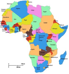
AFRICA
Africa is the world’s second-largest and second-most-populous continent. At about 30.2 million km2 (11.7 million sq mi) including adjacent islands, it covers six percent of the Earth’s total surface area and 20.4 percent of the total land area. With 1.1 billion people as of 2013, it accounts for about 15% of the world’s human population. The continent is surrounded by the Mediterranean Sea to the north, both the Suez Canal and the Red Sea along the Sinai Peninsula to the northeast, the Indian Ocean to the southeast, and the Atlantic Ocean to the west. The continent includes Madagascar and various archipelagos. It has 54 fully recognized sovereign states (“countries”), nine territories and two de facto independent states with limited or no recognition. Africa’s population is the youngest among all the continents; 50% of Africans are 19 years old or younger. Algeria is Africa’s largest country by area, and Nigeria is the largest by population. Africa, particularly central Eastern Africa, is widely accepted as the place of origin of humans and the Hominidae clade (great apes), as evidenced by the discovery of the earliesthominids and their ancestors, as well as later ones that have been dated to around seven million years ago, includingSahelanthropus chadensis, Australopithecus africanus, A. afarensis, Homo erectus, H. habilis and H. ergaster – with the earliestHomo sapiens (modern human) found in Ethiopia being dated to circa 200,000 years ago. Africa straddles the equator and encompasses numerous climate areas; it is the only continent to stretch from the northern temperate to southern temperate zones.From Wikipedia, the free encyclopedia
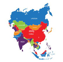
ASIA
Asia is the Earth’s largest and most populous continent, located primarily in the eastern and northern hemispheres. Though it covers only 8.7% of the Earth’s total surface area, it comprises 30% of earth’s land area, and has historically been home to the bulk of the planet’s human population (currently roughly 60%). Asia is notable for not only overall large size and population, but unusually dense and large settlements as well as vast barely populated regions within the continent of 4.4 billion people. Asia has exhibited economic dynamism (particularly East Asia) as well as robust population growth during the 20th century, but overall population growth has since fallen to world average levels.The boundaries of Asia are culturally determined, as there is no clear geographical separation between it and Europe, which together form one continuous landmass called Eurasia. The most commonly accepted boundaries place Asia to the east of the Suez Canal, the Ural River, and the Ural Mountains, and south of the Caucasus Mountains (or the Kuma–Manych Depression) and the Caspian and Black Seas. It is bounded on the east by the Pacific Ocean, on the south by the Indian Ocean and on the north by the Arctic Ocean.Given its size and diversity, the concept of Asia – a name dating back to classical antiquity – may actually have more to do with human geography than physical geography.[6] Asia varies greatly across and within its regions with regard to ethnic groups, cultures, environments, economics, historical ties and government systems.From Wikipedia
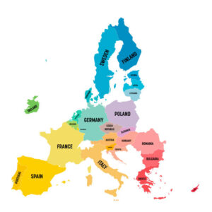
EUROPE
The European Union (EU) is a politico-economic union of 28 member states that are located primarily in Europe. The EU operates through a system of supranational institutions and intergovernmental negotiated decisions by the member states. The institutions are: the European Commission, the Council of the European Union, the European Council, the Court of Justice of the European Union, the European Central Bank, the Court of Auditors, and the European Parliament. The European Parliament is elected every five years by EU citizens. The EU traces its origins from the European Coal and Steel Community (ECSC) and the European Economic Community (EEC), formed by the Inner Six countries in 1951 and 1958, respectively. In the intervening years, the community and its successors have grown in size by the accession of new member states and in power by the addition of policy areas to its remit. The Maastricht Treaty established the European Union under its current name in 1993 and introduced the European Citizenship.[17] The latest major amendment to the constitutional basis of the EU, the Treaty of Lisbon, came into force in 2009. The EU has developed a single market through a standardised system of laws that apply in all member states. Within theSchengen Area, passport controls have been abolished.[18] EU policies aim to ensure the free movement of people, goods, services, and capital,[19] enact legislation in justice and home affairs, and maintain common policies on trade, agriculture, fisheries, and regional development. The monetary union was established in 1999 and came into full force in 2002. It is currently composed of 18 member states that use the euro as their legal tender. Through the Common Foreign and Security Policy, the EU has developed a role in external relations and defence. The union maintains permanent diplomatic missions throughout the world and represents itself at theUnited Nations, the WTO, the G8, and the G-20. With a combined population of over 500 million inhabitants, or 7.3% of the world population, the EU in 2012 generated a nominal gross domestic product (GDP) of 16.584 trillion US dollars, constituting approximately 23% of global nominal GDP and 20% when measured in terms of purchasing power parity. If it were a country, the EU would come first in nominal GDP and second in GDP (PPP) in the world. In 2012, the EU was awarded the Nobel Peace Prize.From Wikipedia The boundaries of Asia are culturally determined, as there is no clear geographical separation between it and Europe, which together form one continuous landmass called Eurasia. The most commonly accepted boundaries place Asia to the east of the Suez Canal, the Ural River, and the Ural Mountains, and south of the Caucasus Mountains (or the Kuma–Manych Depression) and the Caspian and Black Seas. It is bounded on the east by the Pacific Ocean, on the south by the Indian Ocean and on the north by the Arctic Ocean.Given its size and diversity, the concept of Asia – a name dating back to classical antiquity – may actually have more to do with human geography than physical geography.[6] Asia varies greatly across and within its regions with regard to ethnic groups, cultures, environments, economics, historical ties and government systems.From Wikipedia

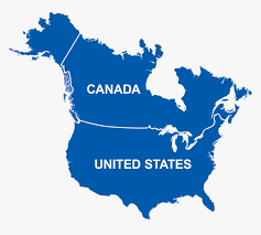
LATIN AMERICA, NORTH AMERICA & THE CARIBBEAN
Latin America Latin America or Romance-speaking America is the sub-region of the Americas comprising those countries where Romance languages are spoken, primarily Spanish and Portuguese. It consists of twenty sovereign states which cover an area that stretches from the southern border of the United States to the southern tip of South America, including the Caribbean. Latin America has an area of approximately 19,197,000 km2 (7,412,000 sq mi), almost 13% of the earth’s land surface area. As of 2013, its population was estimated at more than 604 million and in 2014, LA has a combined nominal GDP of 5,573,397 million USD[4](almost equal to those of the UK and France combined), and a GDP PPP of 7,531,585 million USD (larger than those of India, and Japan and the UK combined). The term “Latin America” was first used in 1861 in La revue des races Latines, a magazine “dedicated to the cause of Pan-Latinism”.North America is a continent wholly within the Northern Hemisphere and almost wholly within the Western Hemisphere. It can also be considered a northern subcontinent of the Americas.[1] It is bordered to the north by the Arctic Ocean, to the east by the Atlantic Ocean, to the west and south by the Pacific Ocean, and to the southeast by South America and the Caribbean Sea.North America North America covers an area of about 24,709,000 square kilometers (9,540,000 square miles), about 4.8% of the planet’s surface or about 16.5% of its land area. As of 2013, its population was estimated at nearly 565 million people across 23 independent states, representing about 7.5% of the human population. Most of the continent’s land area is dominated by Canada, the United States, Greenland, and Mexico, while smaller states exist in the Central American and Caribbean regions. North America is the third largest continent by area, following Asia and Africa,[2] and the fourth by population after Asia, Africa, and Europe.[3]The first people to live in North America were Paleoindians who began to arrive during the last glacial period by crossing the Bering land bridge. They differentiated into a number of diverse cultures and communities across the continent. The largest and most advanced Pre-Columbian civilizations in North America were the Aztecs in what is now Mexico and the Maya in Central America. European colonists began to arrive starting in the 16th and 17th centuries, wiping out large numbers of the native populations and beginning an era of European dominance.Caribbean The Caribbean is a region that consists of the Caribbean Sea, its islands (some surrounded by the Caribbean Sea and some bordering both the Caribbean Sea and the North Atlantic Ocean), and the surrounding coasts. The region is southeast of the Gulf of Mexicoand the North American mainland, east of Central America, and north of South America. Situated largely on the Caribbean Plate, the region comprises more than 700 islands, islets, reefs, and cays. (See the list.) These islands generally form island arcs that delineate the eastern and northern edges of the Caribbean Sea. The Caribbean islands, consisting of the Greater Antilles on the north and the Lesser Antilles on the south and east (including the Leeward Antilles), are part of the somewhat larger West Indies grouping, which also includes the Lucayan Archipelago (comprising the Bahamas andTurks and Caicos Islands) north of the Greater Antilles and Caribbean Sea. In a wider sense, the mainland countries of Belize, Guyana, and Suriname may be included. Geopolitically, the Caribbean islands are usually regarded as a subregion of North America and are organized into 30 territories including sovereign states, overseas departments, and dependencies. From January 3, 1958, to May 31, 1962, there was a short-lived country called the Federation of the West Indies composed of ten English-speaking Caribbean territories, all of which were then British dependencies. The West Indies cricket team continues to represent many of those nations.From Wikipedia
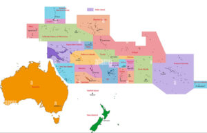
OCEANIA
Oceania also known as Oceanica, is a region centred on the islands of the tropical Pacific Ocean. Opinions of what constitutes Oceania range from its three subregions of Melanesia, Micronesia, and Polynesia to, more broadly, the entire insular region between Asia and the Americas, including Australasia and the Malay Archipelago.The term is often used more specifically to denote a continent comprising Australia and proximate islands or biogeographically as a synonym for either the Australasian ecozone (Wallacea and Australasia) or the Pacific ecozone (Melanesia, Polynesia, and Micronesia apart either from New Zealand[11] or from mainland New Guinea).As an ecozone, Oceania includes all of Micronesia, Fiji, and all of Polynesia except New Zealand. New Zealand, along with New Guinea and nearby islands, part of Philippines islands, Australia, the Solomon Islands, Vanuatu, and New Caledonia, constitute the separate Australasian ecozone. In geopolitical terms, however, New Zealand, the Solomon Islands, Vanuatu and New Caledonia are almost always considered part of Oceania, and Australia and Papua New Guinea are usually considered part of Oceania too. Sometimes Papua province in Indonesia may be included, as Puncak Jaya is often considered the highest peak in OceaniaCountries of Australia and Oceania The “continent” of Australia/Oceania is a somewhat artificial construct, designed to link together the continental landmass of Australia with the huge number of widely scattered islands across the Pacific Ocean.Area: 8 600,000 km2 (3 300,000 mi2) Population: 37 million Highest Point: Puncak Jaya (Carstensz Pyramid 4884 m/16 023 ft), Papua Province, Indonesia Largest Lake: Lake Eyre, Australia (if there is some water) Longest River: Murray-Darling river system 3750 km (2300 mi)Languages of Oceania: Melanesian pidgin, Melanesian-Polynesian Languages, English, French.From Wikipedia
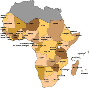
SUB-SAHARA AFRICA
Sub-Saharan Africa is, geographically, the area of the continent of Africa that lies south of the Sahara Desert. Politically, it consists of all African countries that are fully or partially located south of the Sahara (excluding Sudan, even though Sudan sits in the Eastern portion of the Sahara desert). It contrasts with North Africa, which is considered a part of the Arab world. Somalia, Djibouti, Comoros, and Mauritania are geographically part of Sub-Saharan Africa, but also part of the Arab world. The Sahel is the transitional zone between the Sahara and the tropical savanna (the Sudan region) and forest-savanna mosaic to the south. Since probably 3500 B.C.E, the Saharan and Sub-Saharan regions of Africa have been separated by the extremely harsh climate of the sparsely populated Sahara, forming an effective barrier interrupted by only the Nile River in Sudan, though the Nile was blocked by the river’s cataracts. The Sahara Pump Theory explains how flora and fauna (including Homo sapiens) left Africa to penetrate the Middle East and beyond. African pluvial periods are associated with a “wet Sahara” phase during which larger lakes and more rivers existed. The use of the term has been criticized because it refers to the South only by cartography conventions and projects a connotation of inferiority; a vestige of colonialism, which some claim, divided Africa into European terms of homogeneity.From Wikipedia