

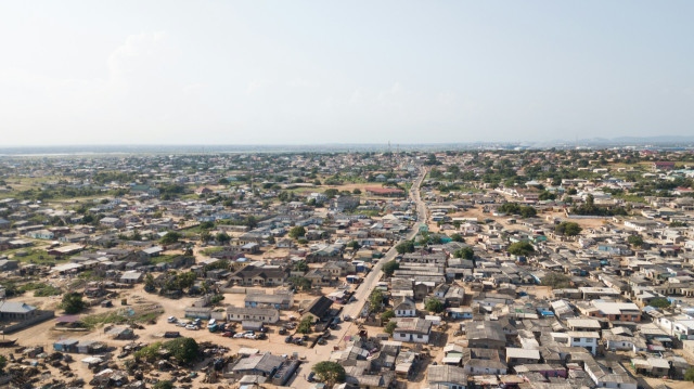
Mapping Informal Settlements Ethically: Privacy, Safety, And Consent
The use of informal settlements mapping has been a rapidly
growing trend in urban planning, humanitarian response, public health and
development policy. Geospatial innovations, satellite imagery, drones, and
participatory mapping tools have enabled the documentation of previously
invisible spaces to formal governance systems in an easier than ever manner.
The informal settlements, which are commonly defined by the lack of tenure to
land, poor services, and marginalization, are not included in the official
maps, which results in underinvestment and neglect. Ethical mapping can be used
to facilitate service delivery, disaster preparedness, and claims of
recognition by residents.
Nevertheless, there
are serious ethical issues concerning mapping these settlements as well.
Informal communities are not simply physical areas, but they house vulnerable
groups, whose privacy, security, and independence can be threatened by data
gathering. Mapping projects poorly managed may put the residents at risk of
eviction, surveillance, criminalization, or exploitation.
This blog addresses the ethical aspects of informal
settlement mapping with reference to privacy, safety, and consent. It also
states that mapping can never be a technical neutral procedure, but rather a
political and ethical intervention that should be informed by accountability,
inclusivity, and respect of the community agency.
The Politics of Visibility in Informal Settlement.
Mapping informal settlements essentially transforms their
visibility and the visibility is highly political. Most informal settlements in
the past have been in a deliberately non-visibility state, not recorded by the
official books and omitted in urban plans. Although invisibility most of the
time results in negligence, visibility can also open up, requesting regulation,
monitoring, and displacement. By mapping settlements, governments, investors,
and law enforcers can see them. Such legibility can be an empowering aspect
when it results in service delivery, acknowledgment, and may also be quite
perilous when it enables eviction or oppression.
Mapping ethics are thus determined by the party that
dictates the story that maps tell. Maps should not be perceived as neutral
depictions of the reality; they are based upon priorities, values, and power
relations of their creators. The problem with mapping informal settlements by
the outside players without involving the communities is that they are likely
to reproduce the top-down views that such spaces are something to be remedied
and not communities to be served. Punitive policies can be justified by labels
that are part of the map, e.g. slum, illegal, or encroachment.
Visibility is a cause of concern in timing and intent as
well. Mapping can also be used before forced displacement in situations where
land prices are increasing or when the political authorities demand the
clean-up process of cities. Inhabitants can discover that information gathered
in the pretext of development is eventually used to their disadvantage. When it
comes to ethical mapping, one should take into consideration whether greater
visibility will really help beneficially and not hurt residents. This requires
the change in the perception of mapping as a technical undertaking to the
identification of mapping as an intervention with actual social implications.
Privacy Risks in Mapping Informal Settlements
One of the most vital ethical issues in mapping of the
informal settlements is privacy. Geospatial data can be rich with the exact
data on the location of houses, what the buildings are constructed of, access
to infrastructure and population density. This information together with other
datasets may expose sensitive information regarding the livelihood of the
residents, their migration status, or their legal vulnerability. Privacy
violations can be disastrous in informal settlements, where people usually do
not have legal tenure of their houses or other forms of identifications.
These risks have been compounded by technological
innovations. Intimate details of daily life can be taken with ease with the
high-resolution satellite applied or using drone mapping without the knowledge
or permission of the residents. Spatial data can be re-identified even in small
or densely clustered communities even in cases where individual names are not
recorded. When data has been digitized and shared it becomes hard to determine
who could have accessed the information and what the purpose is. Information
that can be utilized in humanitarian planning can subsequently be utilized by
the authorities to impose zoning regulations or by individual developers
interested in purchasing land.
Data governance models that confer privacy should be put up
in order to perform ethical mapping. This involves keeping the data collected
to the bare minimum, anonymizing the sensitive data, and ensuring a safe method
of data storage. Notably, privacy is no longer a personal but a social issue.
Mapping a whole settlement may put the settlement at risk, although individual
identities may be kept confidential. Privacy respect implies involving
communities in making their own decisions concerning what data is gathered, and
how it is depicted and accessible to whom.
The Risk of Harm and Safety Concerns.
The issue of safety is not only on data privacy, but also on
the physical, legal, and social dangers of mapping. Informal settlements, in
most situations, live in precarious conditions with authorities. Surveying or
drone flights, or the use of GPS data, can be of interest and cause concerns
when mapped. The residents will be afraid that mapping is associated with
eviction, taxes, or policing. Mappers might be met with hostility or even
violence in a few instances, especially when communities are threatened or
deceived.
Safety risks may also be dangerous due to the spread of
maps. Criminal groups can use publicly accessible maps with settlement layouts,
paths or infrastructure to justify heavy-handed interventions or use them to
justify criminal actions. When there is conflict or a political upheaval, the
mapped data can be used as an instrument of targeting the disadvantaged
populations. Well-meant humanitarian maps may be known to unwillingly reveal
weaknesses, including dark spots or entry points.
Ethical mapping requires an offensive strategy that puts the welfare of residents first rather than the objectives of data completeness or accuracy. This involves the evaluation of possible risks prior to the commencement of mapping and the willingness to stop or alter projects in the event of change of conditions. The issues of data resolution, open access, and long-term storage must be determined based on safety considerations. More importantly, communities themselves are better placed to determine what risks they are exposed to and that is the reason why participatory approaches are important.

Consent as a Process and a Process that is Continuous.
Consent can be considered a procedural checkbox, yet it is
necessary to perceive it as a communal and continuous process when it comes to
the mapping of informal settlements. Single informed consent can be inadequate
in situations where mapping is done in whole neighborhoods. Where there is an
imbalance in power and use of technical language residents may not have a full
understanding of how the spatial data will be used or shared. True consent must
be transparent, dialogical and free to say no to participation without any
adverse ramifications.
Collective consent acknowledges that informal settlements
are social units that have common dangers and interests. Community leaders,
grassroots organizations and resident associations are very important in
getting the discussions regarding mapping projects. Nevertheless, the reliance
on the gatekeepers will exclude the voices of marginalized groups of people in
the community, including tenants, women, or undocumented residents. The ethical
consent procedures should thus be participatory and considerate of in-house
power relations.
Consent is also to be revisited after some time. Today is
not today tomorrow since what is being gathered today can be used tomorrow in a
different manner because of the changing of technologies and political
scenario. Communities should be able to pull out of the mapping practices,
demand the deletion of data, or reformulate the terms of use. The understanding
of consent as a continuing relationship as opposed to a single agreement is
important in ensuring that mapping does not become irresponsible to its subjects.
Participatory Mapping and Community Agency
Participatory mapping is usually brought out as an ethical
approach to the dilemma of mapping informal settlements. Participatory methods
can achieve accuracy, legitimacy and empowerment by engaging residents in data
gathering and interpretation. Communities map their own space, and thus are
able to make decisions about what is included or not, creating stories that are
based on lived experiences instead of preconceived notions.
Practicality is not enough to produce ethical results
however. Participatory mapping may continue to recreate inequalities provided
that there is domination by some groups in the process or when the data is
controlled by other bodies. Equitable allocation of training, resources and
decision making power should be done to prevent tokenism. Long-term engagement,
capacity building and respect to local knowledge systems are some of the
requirements of ethical participatory mapping.
There is also community agency where there is ownership of
data. In many instances, information gathered with the involvement of the
community is usually taken away and kept in external institutions, thereby
depriving the residents of the opportunity to utilize them in their own
advocacy. Ethical mapping can be used to give the community control over the
data, so that residents can utilize maps to make claims against services,
disaster preparedness, or tenure agreements. By strengthening community agency
through mapping, there will be more chances to improve safety and respect
consent.
Digital Inequality and Power Asymmetries
The mapping of informal settlements is done in the larger
framework of digital disparity and unequal power. The availability of
technology, technical skills, and data infrastructure is not equally divided
and in many instances, it is a distributed advantage to governments, NGOs, and
the privately owned firms than the residents themselves. This imbalance
influences the interests that are prioritized and voices that are heard.
Mapping platforms deployed digitally, can instill some
standardized categories that are not related to local realities. Photo-tenure
systems, social networks and livelihood systems might be challenging to capture
under traditional mapping systems. Simplification and misclassifying of data
can result in distortion of policy responses and marginalization of other forms
of knowledge.
Ethical mapping should therefore face issues of power
directly. The mapping practitioners must be able to address these issues
through reflexivity and accountability. It also requires structural adjustment
to facilitate digital inclusion, including community education, open-source
applications, and equitable data-sharing policies.
Legal Systems and Accountability Structures.
Legal and institutional frameworks are important in
determining the ethics of mapping informal settlements. Mapping data can be
collected and used in different variations based on the data protection laws,
land governance systems and human rights standards. Laws have little power or
are not enforced in most of the countries, and as a result, citizens are at the
mercy of abusing information.
To provide ethical practice, accountability mechanisms are
necessary. These can be in the form of ethical review boards, community
oversight committees or commitment agreements that limit use of data. It is
also essential to be open to sources of funding, project goals, and
collaborations. In cases where mapping initiatives are associated with
government agencies or those developed by privates, ethical risks are greater,
and accountability becomes even more significant.
Ethical mapping in informal settlements can be changed
through legal recognition. In places where the residents have a safe tenure and
legal protection, the mapping would not lead to putting them in jeopardy. On
the contrary, in case of lawlessness and oppression, the greatest care is
justified. Ethical mapping is inseparable with more encompassing housing rights
and urban justice struggles.
Ethical Mapping in Humanitarian and Crisis Contexts
Mapping of informal settlements tends to become worse in the
event of a humanitarian crisis like natural disaster, disease outbreak or
forced displacement when there is a perceived need to create data fast to
action to deal with the emergency. The moralities of mapping are especially
high in such circumstances. Although timely maps could be used to help save
lives through flood prone zone identification, vulnerable population location,
or aid distribution planning, the timely maps might put at risk already vulnerable
populations. When the conditions of crisis are in play, timelines are usually
tightened, and the consent procedures are weakened, and it becomes simpler to
ignore the ethical protection mechanisms.
External factors, such as the international NGOs, UN
agencies, or even the technology companies, often do the mapping in case of an
emergency and are not fully aware of the local power structure. The information
received in emergency circumstances can subsequently be reused to
non-humanitarian ends, e.g. city rebuilding or counterinsurgency activities.
The boundary between humanitarian aid and surveillance can become unclear to
the population of informal settlements so that mistrust is lost, and the fear
is enhanced. The use of ethical mapping in crisis environments must thus have
very specific parameters surrounding the utilization of data which have very
rigid prohibitions on distributing information outside of the direct
humanitarian reasoning.
The subject of consent in times of crises is a special
challenge. The residents might also be forced to collaborate with mapping
activities in anticipation of getting aid, despite their privacy and security
concerns. This poses a danger of forced consent, in which they are involved due
to the neediness and not on the basis of agreement. Ethical practice requires
that the consent should be considered meaningful which includes during
emergencies and that the failure to consent does not lead to the failure to receive
assistance. In case of an inability to provide full informed consent,
practitioners ought to use harm-minimization goal, which includes gathering
only the necessary data and does not involve high-resolution or identifiable
data.
Another critical aspect is that one should be answerable
after the crisis. Mapping initiatives should have clear road maps of how the
information should be stored, destroyed and community response once the
emergency is past. The regaining of agency and transparency will involve a
restoration of mapped information to communities in consumable forms. Lastly,
in case of humanitarian cases, there should always be a balance between
expedience and caution in an ethical mapping exercise, where the necessity to
act in time should not override the fundamental rights and safety of the
residents of the informal settlements.
Conclusion
It takes more than expertise and intentions to map informal settlements ethically. It requires profound dedication to privacy, safety, consent, based on respect towards community agency and sensitivity to power relations. The maps may be empowering or destructive (depending on their production and use). Ethical mapping acknowledges the fact that data is not neutral, as well as visibility and consent are not a facade.
Mapping initiatives can help make cities more fair and inclusive by prioritizing the voices and interests of residents, enhancing data governance, and implementing accountability in each step of the process. After all, it is not the issue of making informal settlements visible at any price but it is the issue of making sure that such visibility is dignified, rightful and in the best interest of the whole society.
Also Read: Agency of Mapping in South Asia: Galle-Matara (Sri Lanka), Mumbai (India) and Khulna (Bangladesh)





-3dkuLgKhRD.jpg)
-49HupTvwDD.jpg)







LEAVE A REPLY